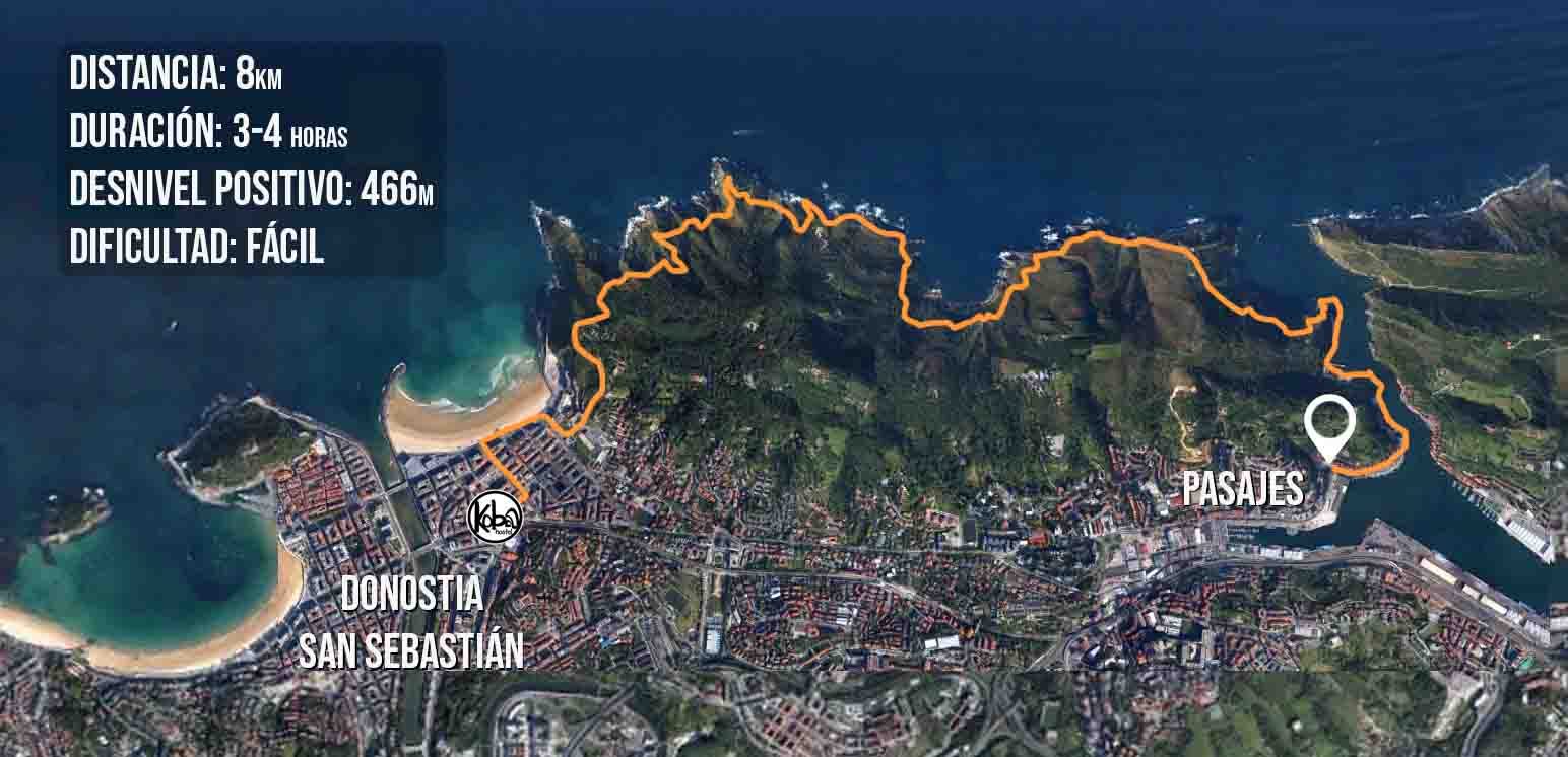
The Ulia Path, also known as “the cliffs route,” follows part of the Camino de Santiago that connects the Gros neighborhood with Pasajes Bay, through 8 kilometers of trail with spectacular landscapes. This path is located on one of the most violent and vertical cliffs on the Basque coast. The walk takes about 3 hours and is not very difficult, although it has some small slopes that require a certain level of physical fitness.
DESCRIPTION OF THE ROUTE
1.
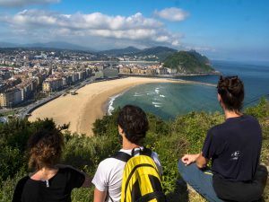
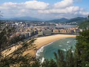
We have to follow the red and white marks (GR). Starting from the Gros neighborhood, before the end of Zurriola beach, the Corazón de María church marks the beginning of the climb to Ulia just at its junction with the gas station. The ascent is steep and a bit rough at first, but the route soon reaches an asphalt road that flattens out. Soon we reach a viewpoint, which if the vegetation allows it, offers excellent views of the city. We will continue along the path, venturing into a forest.
Just 200m after the viewpoint, we find a small detour to the left and take this narrow path, leaving the main path to continue towards the Ulia picnic area.
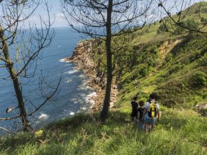
2. This narrow path continues its steep climb upwards, and after overcoming this tough slope, we reach an elevated and open area called “Kutralla gaina”, where the view changes completely. Here we can see the first cliffs of Ulia, home to a large colony of seagulls. From this point, another path ascends towards the summit area of Ulia and its watchtower, but our route continues on level ground, gradually ascending to overcome the abrupt cliff that drops steeply into the sea.
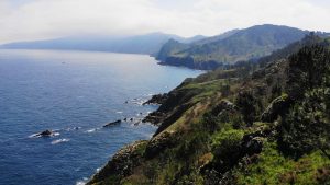
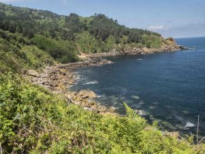
3. From Kutralla, we will continue along the descending trail. After passing through the old laundry area, we will take the left turn. Gradually, the path becomes a stone road that leads to the viewpoint that offers us views towards the Monpas point. Soon, the forest opens up, and we will see the Animeta point and the rocks of Atalaundi. From here, on clear days, we can not only see Biarritz but also the coast of Les Landes. Heather, ferns, and aromatic plants are the most common plants in the area, interspersed with occasional pines and oaks, the latter of which once covered most of the mountain.
4. Once we reach the Atalaundi area, near the Animeta point, we come across another fork in the path. From here, one trail ascends to the summit of Ulia, and another descends towards the Atalaundi rocks or continues towards the coastal path that gets closer to the sea. We take the path that descends. From here, the path constantly goes up and down until we reach the area of the Emisario House, where the water collector is located. Here we take the concrete track uphill and resume the trail that continues along the mid-slope path towards Pasajes.
5.
Before reaching the area of Mendiola Bay, we take a left turn and begin to descend towards the vicinity of this bay. In Mendiola, the trail surprises us with another new facet of Ulia: the water paths. Here, it can sometimes be difficult to find the way. There comes a point where the path splits into three, one path goes down, another goes up, and another, more difficult to find, follows the mid-slope, which is the one we should take. If we continue along this path, we will reach a narrow 200m-long tunnel that we must cross, and then we will reach several aqueducts. These tunnels and aqueducts were built in the 19th century to carry water collected from the streams and springs of Ulia to the city.
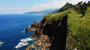
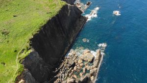
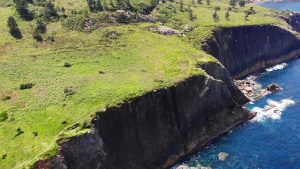
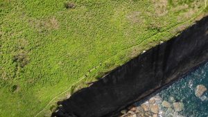
The second aqueduct takes us directly to the most impressive cliffs of the trail. Here, the path runs close to the vertical and spectacular sandstone walls.
Gradually, advancing through ferns, we will head towards the Plata lighthouse, located on an impressive almost-perpendicular cliff at a height of 163m above sea level, until we reach the esplanade beneath it. The lighthouse’s name comes precisely from the silver color with which its large slabs are tinted, battered by the waves.
6. From here, the access road to the lighthouse will take us closer to Pasaia. We take the road and after about 300m we take a path to the left that leads us to the Senokozuloa stairs that will take us down to the mouth of the Pasajes Bay. Ulia was once a single mountain together with Jaizkibel, Urgull, and the Santa Clara island, which extended as far as Zumaia, and the Pasaia estuary is one of the fractures that water has carved into this coastal chain. Protected by these magnificent mountains, it is an excellent natural anchorage. Following the path at sea level, we will soon reach Albaola, the Basque Maritime Factory, in the former Ondartxo shipyard, where a recreation of the 16th-century whaling ship San Juan is being built.
7.
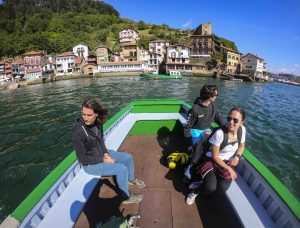
Once we arrive in San Pedro, we are reminded of Victor Hugo’s words that are still relevant today to describe this special place: “A curtain of tall green mountains, their peaks cutting against a radiant sky; at the foot of these mountains, a row of tightly juxtaposed houses, all of these houses painted white, saffron, green, with two or three floors of large balconies, a thousand things floating, clothes drying, nets, red, yellow, blue rags; at the foot of these houses, the sea…This bay lacks no grace; when I look at the horizon that encloses it, it is a lake; when I see the tide rising, it is the sea.” The motora allows us to quickly cross to Donibane. Victor Hugo arrived by chance to this secluded place and decided to stay for a few days. The house where he stayed now houses his museum, which is the endpoint of this route, offering a beautiful walk through the present and the past of this wonderful corner of the Basque coast.
Once the tour is over, it is possible to take a motora that crosses the bay and visit San Juan, a small and picturesque coastal town opposite San Pedro.
To return to Donostia, it is best to take the bus. At the first roundabout in San Pedro, we take the E9 line that will take us back to the Gros neighborhood, where we can get off at the same place where we started the ascent to Ulia.
Some photos of the route
mirador
vistas de Donosti
vista de la costa
acantilados
Bahía de Mendiola
Acantilados
Acantilados
Motora a San Juan
DCIM100GOPROGOPR4327.
This website uses cookies to improve your experience. We'll assume you're ok with this, but you can opt-out if you wish. Cookie settingsACCEPT
Privacy & Cookies Policy
Privacy Overview
This website uses cookies to improve your experience while you navigate through the website. Out of these cookies, the cookies that are categorized as necessary are stored on your browser as they are essential for the working of basic functionalities of the website. We also use third-party cookies that help us analyze and understand how you use this website. These cookies will be stored in your browser only with your consent. You also have the option to opt-out of these cookies. But opting out of some of these cookies may have an effect on your browsing experience.
Necessary cookies are absolutely essential for the website to function properly. This category only includes cookies that ensures basic functionalities and security features of the website. These cookies do not store any personal information.
Any cookies that may not be particularly necessary for the website to function and is used specifically to collect user personal data via analytics, ads, other embedded contents are termed as non-necessary cookies. It is mandatory to procure user consent prior to running these cookies on your website.